A target for every climb — not one average pace for 100 km.
Upload a course GPX and get a per-segment pacing plan built on grade cost, terrain roughness, and duration fade — then run it live on your Garmin.
- No signup to analyse
- Open, cited methodology
- Live Garmin data field
Drop a GPX here, or click to browse
.GPX · max 25 MB · stays private — analysed in your browser first
Flat-pace targets are wrong on trail. Grade, terrain, and fatigue all shift the cost.
The same pace costs far more energy uphill than on the flat. Fixed, set-at-the-start pacing drifts badly on technical trail. Pacevine computes a distinct target for every segment using three layers:
Grade cost
How the energy cost of running changes with slope — steep climbs cost most, a gentle downhill is cheapest, steep descents cost more than flat.
Terrain factor
Surface and technicality, not just gradient — groomed gravel and an alpine scramble at the same gradient are not the same run.
Duration fade
Runners slow over hours regardless of grade. The fade grows with cumulative distance and eccentric load. The plan anchors so your predicted finish equals your goal.
How it works
Upload your GPX
Export from Garmin, COROS, Komoot, or any GPS device. Drop the .gpx file — no account needed.
Set your finish time
Enter a goal finish time. The engine computes a per-segment target using grade, terrain, and duration fade — not a flat-pace average.
Edit aid stops & save
Sign in to save. Add per-aid stop times, set terrain tier per segment, upload the race rules PDF to auto-fill cutoffs and mandatory kit.
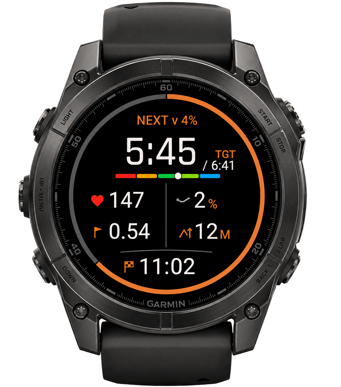
Run it on-watch
Export to the Garmin Connect IQ data field. Live per-segment target vs actual, ahead/behind delta, distance to next aid, projected finish — updated every second.
We show our work — every pace, every assumption.
Every factor is named, every number cited. The elevation gain figure is labelled estimated, never official — because no GPS track exactly matches the race rules. We show both the DEM-corrected figure used for pacing and the raw figure so you know the difference.
“Average pace is a lie on a mountain. A 10 km/h pace on flat costs less energy than 6 km/h uphill at +15%. The plan must pace grade, not distance.”
Two D+ figures are deliberate: the DEM-corrected number the plan paces on, and the raw number for reference. The method is open.
Pricing
Start free, no card. Unlock a single race for $14, or go unlimited with Racer Pro.
Free
$0
forever, no card
- Unlimited GPX analyses
- Per-segment pacing plan (grade + terrain + fade)
- Elevation chart + segment timeline
- Aid station editor
- DEM-corrected elevation readout
Per-Race
$14
one-time, one race
- Everything in Free
- Race rules auto-ingestion (PDF/DOCX)
- Cutoffs + mandatory kit auto-populated
- Garmin JSON export for the data field
- Full plan save + edit
Racer Pro
$69
per year
- Everything in Per-Race, unlimited races
- Live Garmin data field sync
- Ahead/behind + finish ETA on-watch
- Per-checkpoint weathercoming
- Athlete personalization (watch history)coming
Stop guessing. Pace the mountain.
Upload a GPX file — no account, no card. See a full terrain-aware pacing plan in seconds.